
Swegeo DS100D
Survey Grade Echosounder with GNSS
Key Feature
- Multi-GNSS Support: Compatible with major global satellite systems including GPS, GLONASS, GALILEO, BEIDOU, QZSS, and IRNSS.
- Multi-Frequency Compatibility: Receives signals across multiple frequencies for high accuracy and precision.
- Advanced Positioning Services: Supports SBAS and L-Band for correction data, enabling survey-grade positioning performance.
Multi-Constellation GNSS Support
Provides reliable and robust signal reception from GPS, GLONASS, Galileo, and
BeiDou systems, ensuring comprehensive coverage and improved accuracy.
Dual Antenna Configuration
Enhances positioning accuracy and performance, particularly in challenging
environments, by using two antennas to better mitigate signal obstructions and
multipath effects.
Hydrographic Surveying:
The DS100D is a dual-frequency echo sounder system paired with high-precision GNSS, purpose-built for mapping water bodies. Hydrographic surveyors mount the DS100D on boats or unmanned surface vessels to chart riverbeds, lakes, and coastal seafloors. As the echo sounder measures depths, the built-in survey-grade GNSS logs the exact geolocation for each depth reading. This integrated approach greatly simplifies workflow: a single device provides both vertical (depth) and horizontal position data. In practice, a team can scan a reservoir or harbor and produce accurate bathymetric maps that are geo-referenced to real-world coordinates, useful for navigation charts, dredging plans, or environmental monitoring. The rugged design of the DS100D means it handles spray, waves, and weather, while its precise GNSS (supporting RTK and SBAS) ensures that even in wide-open water without nearby reference stations, the positioning of depth measurements is trustworthy.
Dredging and Marine Construction:
Companies involved in dredging channels or constructing bridges/piers deploy the DS100D to monitor underwater progress. By fixing the DS100D on a barge or dredger, operators can continuously measure the depth of the work area and see in real time the position of their equipment relative to the seabed. For example, as a dredger clears sediment, the DS100D provides immediate feedback on depth achieved and the GNSS tag tells the operator exactly where (latitude/longitude) that depth is, preventing under- or over-dredging and ensuring the project meets specifications. When building an offshore structure, engineers can use it to survey the foundation area, then periodically check that depths and underwater shapes remain as expected (detecting any scouring or sedimentation changes due to construction).
Inland Waterway Management:
Government agencies and environmental scientists use the DS100D for monitoring rivers, reservoirs, and canals. The portable nature of the system allows it to be deployed on small survey boats or even mounted on adaptable platforms (like kayaks or remote-controlled boats) for shallow or difficult-to-access waters. As it records depth along with precise coordinates, officials can create up-to-date models of channel conditions, identify shoaling (shallowing) sections that might impede navigation, or monitor sediment build-up behind dams. Because the DS100D combines GNSS and echo sounding in one unit, it reduces errors that could occur when using separate devices (for example, timing mismatches between a depth finder and an external GPS). This all-in-one accuracy is crucial for environmental surveys—like assessing a river after a flood to see how the bottom has shifted, or checking a lake for silting that could affect water storage capacity.


| Feature | Specification | Feature | Specification |
|---|---|---|---|
| Signal Support (Primary RF) |
GPS L1 C/A, L1C, L2C, L2P, L5; GLONASS L1 C/A, L2 C/A, L2P, L3, L5; Galileo E1, E5 AltBOC, E5a, E5b; BeiDou B1I, B1C, B2I, B2a, B2b; QZSS L1 C/A, L1C, L1S, L2C, L5; NavIC (IRNSS) L5; SBAS L1, L5; L-Band up to 5 channels |
Signal Support (Secondary RF) |
GPS L1 C/A, L1C, L2C, L2P, L5; GLONASS L1 C/A, L2 C/A, L2P, L3, L5; Galileo E1, E5 AltBOC, E5a, E5b; BeiDou B1I, B1C, B2I, B2a, B2b; QZSS L1 C/A, L1C, L1S, L2C, L5; NavIC (IRNSS) L5 |
| Horizontal Position Accuracy (RMS) |
Single point L1 1.5 m Single point L1/L2 1.2 m SBAS 60 cm DGPS 40 cm TerraStar-L 40 cm TerraStar-C PRO 2.5 cm RTK 1 cm + 1 ppm ALIGN heading accuracy |
Baseline Accuracy (RMS) |
2 m 0.08° 4 m 0.0° |
| Data Update Rate |
Measurements up to 100 Hz Position up to 100 Hz |
Time to First Fix |
Cold start < 34 s (typ) Hot start < 20 s (typ) |
| Signal Reacquisition |
L1 < 0.5 s (typ) L2 < 1.0 s (typ) |
Velocity Limit | 600 m/s |
| Velocity Accuracy | <0.03 m/s RMS | Time Accuracy | <5 ns RMS |
| Dimensions | 147 x 125 x 55 mm | Weight | 500 g |
| Power Consumption | 3.95 W | Input Voltage | +9 to +36 VDC |
| 2 Antenna LNA Power Output |
Output voltage 5 VDC ±5% Maximum current 200 mA |
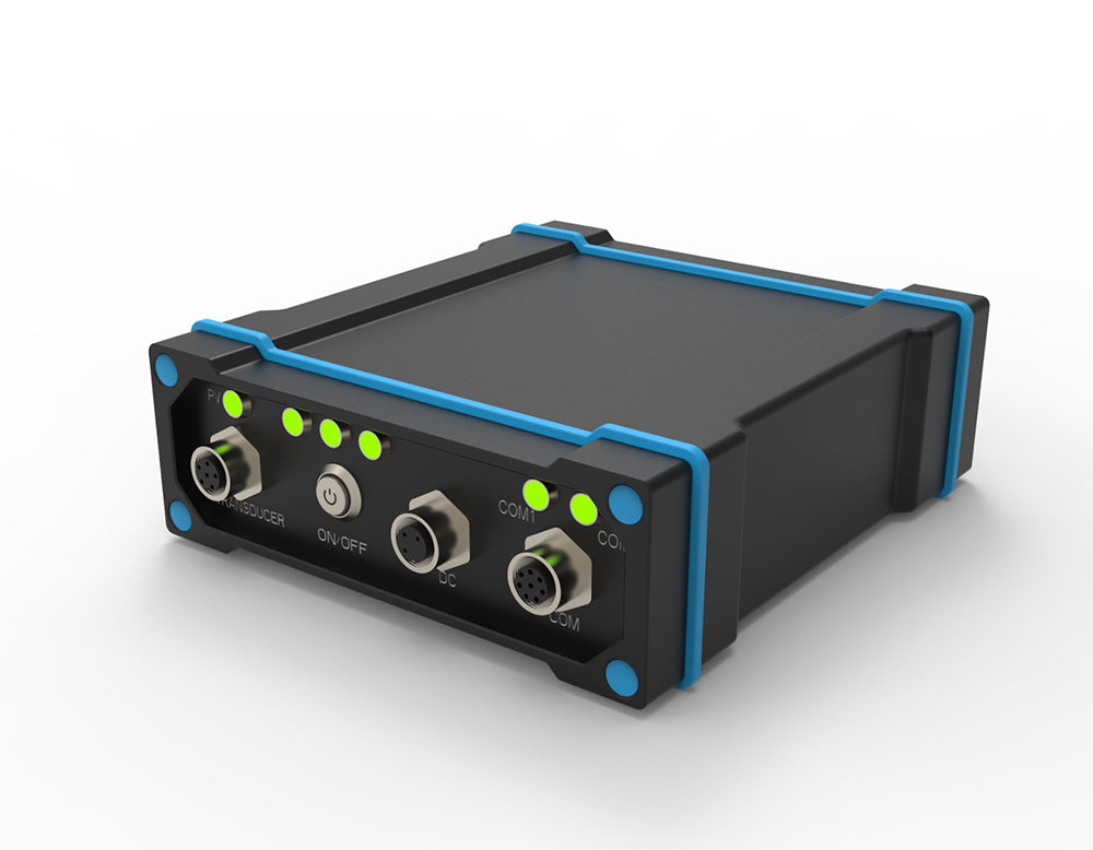
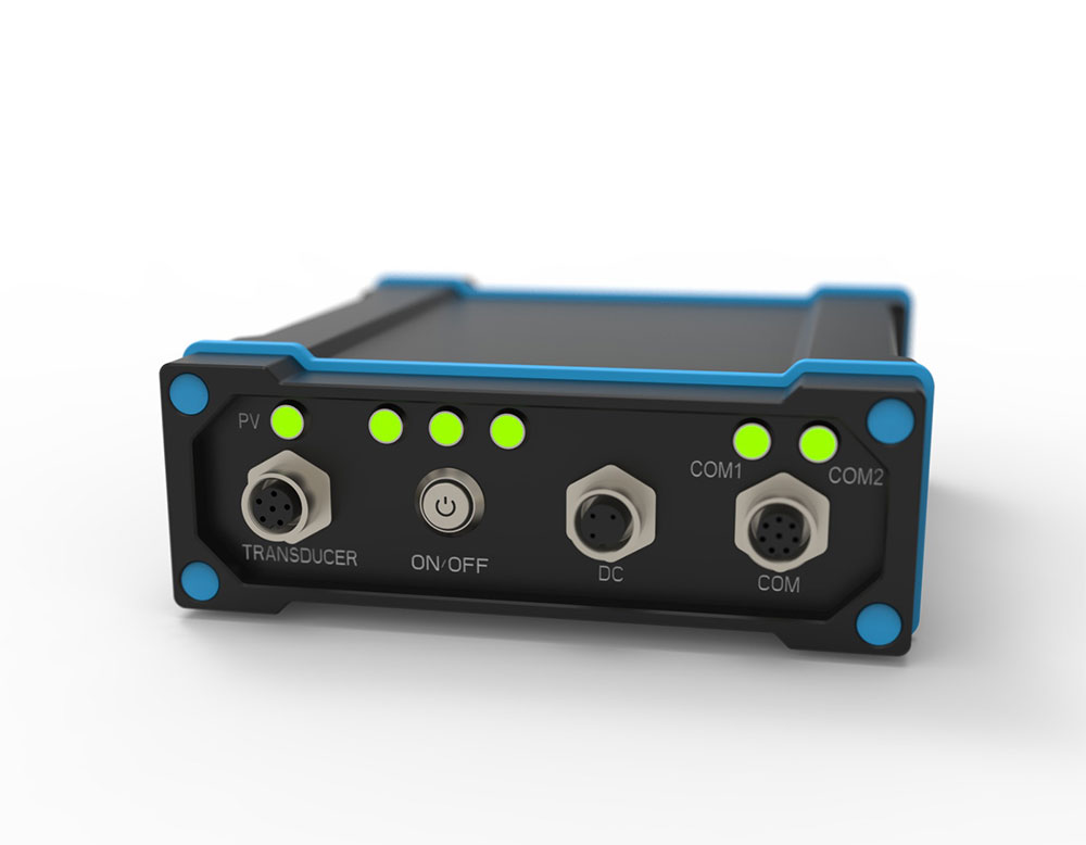
Connectors |
RF 2×TNC USB M12-USB TYPE A Cable Serial M12-2×DB9Y Cable Power M12-3 Wire Cable |
| Status LED | Position Valid, Power, Serial Rx/Tx Stream | Ingress Protection Rating | IP67 |
| Temperature |
Operating -40°C to +75°C Storage -40°C to +85°C |
Humidity | 95% non-condensing |
| Vibration |
Random MIL-STD-810H, Method 514.8 (Cat 24, 20 g RMS) Sinusoidal IEC 60068-2-6 |
Shock / Bump / Acceleration |
Acceleration: MIL-STD-810H, Method 513.8, Procedure II (16 g) Bump: MIL-STD-810H, Method 516.8, Procedure 1 (40 g 11 ms terminal sawtooth) Shock: Random MIL-STD-810H, Method 514.8 (Cat 24, 20 g RMS), Sinusoidal IEC 60068-2-6 |
Swegeo DS100D
Survey Grade Echosounder with GNSS
Key Feature
Multi-GNSS Support: Compatible with major global satellite systems including GPS, GLONASS, GALILEO, BEIDOU, QZSS, and IRNSS.
Multi-Frequency Compatibility: Receives signals across multiple frequencies for high accuracy and precision.
Advanced Positioning Services: Supports SBAS and L-Band for correction data, enabling survey-grade positioning performance.
OVERVIEW
Multi-Constellation GNSS Support
Provides reliable and robust signal reception from GPS, GLONASS, Galileo, and
BeiDou systems, ensuring comprehensive coverage and improved accuracy.
Dual Antenna Configuration
Enhances positioning accuracy and performance, particularly in challenging
environments, by using two antennas to better mitigate signal obstructions and
multipath effects.
USE CASES
Hydrographic Surveying:
The DS100D is a dual-frequency echo sounder system paired with high-precision GNSS, purpose-built for mapping water bodies. Hydrographic surveyors mount the DS100D on boats or unmanned surface vessels to chart riverbeds, lakes, and coastal seafloors. As the echo sounder measures depths, the built-in survey-grade GNSS logs the exact geolocation for each depth reading. This integrated approach greatly simplifies workflow: a single device provides both vertical (depth) and horizontal position data. In practice, a team can scan a reservoir or harbor and produce accurate bathymetric maps that are geo-referenced to real-world coordinates, useful for navigation charts, dredging plans, or environmental monitoring. The rugged design of the DS100D means it handles spray, waves, and weather, while its precise GNSS (supporting RTK and SBAS) ensures that even in wide-open water without nearby reference stations, the positioning of depth measurements is trustworthy.
Dredging and Marine Construction:
Companies involved in dredging channels or constructing bridges/piers deploy the DS100D to monitor underwater progress. By fixing the DS100D on a barge or dredger, operators can continuously measure the depth of the work area and see in real time the position of their equipment relative to the seabed. For example, as a dredger clears sediment, the DS100D provides immediate feedback on depth achieved and the GNSS tag tells the operator exactly where (latitude/longitude) that depth is, preventing under- or over-dredging and ensuring the project meets specifications. When building an offshore structure, engineers can use it to survey the foundation area, then periodically check that depths and underwater shapes remain as expected (detecting any scouring or sedimentation changes due to construction).
Inland Waterway Management:
Government agencies and environmental scientists use the DS100D for monitoring rivers, reservoirs, and canals. The portable nature of the system allows it to be deployed on small survey boats or even mounted on adaptable platforms (like kayaks or remote-controlled boats) for shallow or difficult-to-access waters. As it records depth along with precise coordinates, officials can create up-to-date models of channel conditions, identify shoaling (shallowing) sections that might impede navigation, or monitor sediment build-up behind dams. Because the DS100D combines GNSS and echo sounding in one unit, it reduces errors that could occur when using separate devices (for example, timing mismatches between a depth finder and an external GPS). This all-in-one accuracy is crucial for environmental surveys—like assessing a river after a flood to see how the bottom has shifted, or checking a lake for silting that could affect water storage capacity.
APPLICATIONS
TECHNICAL SPECIFICATIONS
| Feature | Specification | Feature | Specification |
|---|---|---|---|
| Signal Support (Primary RF) |
GPS L1 C/A, L1C, L2C, L2P, L5; GLONASS L1 C/A, L2 C/A, L2P, L3, L5; Galileo E1, E5 AltBOC, E5a, E5b; BeiDou B1I, B1C, B2I, B2a, B2b; QZSS L1 C/A, L1C, L1S, L2C, L5; NavIC (IRNSS) L5; SBAS L1, L5; L-Band up to 5 channels |
Signal Support (Secondary RF) |
GPS L1 C/A, L1C, L2C, L2P, L5; GLONASS L1 C/A, L2 C/A, L2P, L3, L5; Galileo E1, E5 AltBOC, E5a, E5b; BeiDou B1I, B1C, B2I, B2a, B2b; QZSS L1 C/A, L1C, L1S, L2C, L5; NavIC (IRNSS) L5 |
| Horizontal Position Accuracy (RMS) |
Single point L1 1.5 m Single point L1/L2 1.2 m SBAS 60 cm DGPS 40 cm TerraStar-L 40 cm TerraStar-C PRO 2.5 cm RTK 1 cm + 1 ppm ALIGN heading accuracy |
Baseline Accuracy (RMS) |
2 m 0.08° 4 m 0.0° |
| Data Update Rate |
Measurements up to 100 Hz Position up to 100 Hz |
Time to First Fix |
Cold start < 34 s (typ) Hot start < 20 s (typ) |
| Signal Reacquisition |
L1 < 0.5 s (typ) L2 < 1.0 s (typ) |
Velocity Limit | 600 m/s |
| Velocity Accuracy | <0.03 m/s RMS | Time Accuracy | <5 ns RMS |
| Dimensions | 147 x 125 x 55 mm | Weight | 500 g |
| Power Consumption | 3.95 W | Input Voltage | +9 to +36 VDC |
| 2 Antenna LNA Power Output |
Output voltage 5 VDC ±5% Maximum current 200 mA |
Connectors |
RF 2×TNC USB M12-USB TYPE A Cable Serial M12-2×DB9Y Cable Power M12-3 Wire Cable |
| Status LED | Position Valid, Power, Serial Rx/Tx Stream | Ingress Protection Rating | IP67 |
| Temperature |
Operating -40°C to +75°C Storage -40°C to +85°C |
Humidity | 95% non-condensing |
| Vibration |
Random MIL-STD-810H, Method 514.8 (Cat 24, 20 g RMS) Sinusoidal IEC 60068-2-6 |
Shock / Bump / Acceleration |
Acceleration: MIL-STD-810H, Method 513.8, Procedure II (16 g) Bump: MIL-STD-810H, Method 516.8, Procedure 1 (40 g 11 ms terminal sawtooth) Shock: Random MIL-STD-810H, Method 514.8 (Cat 24, 20 g RMS), Sinusoidal IEC 60068-2-6 |