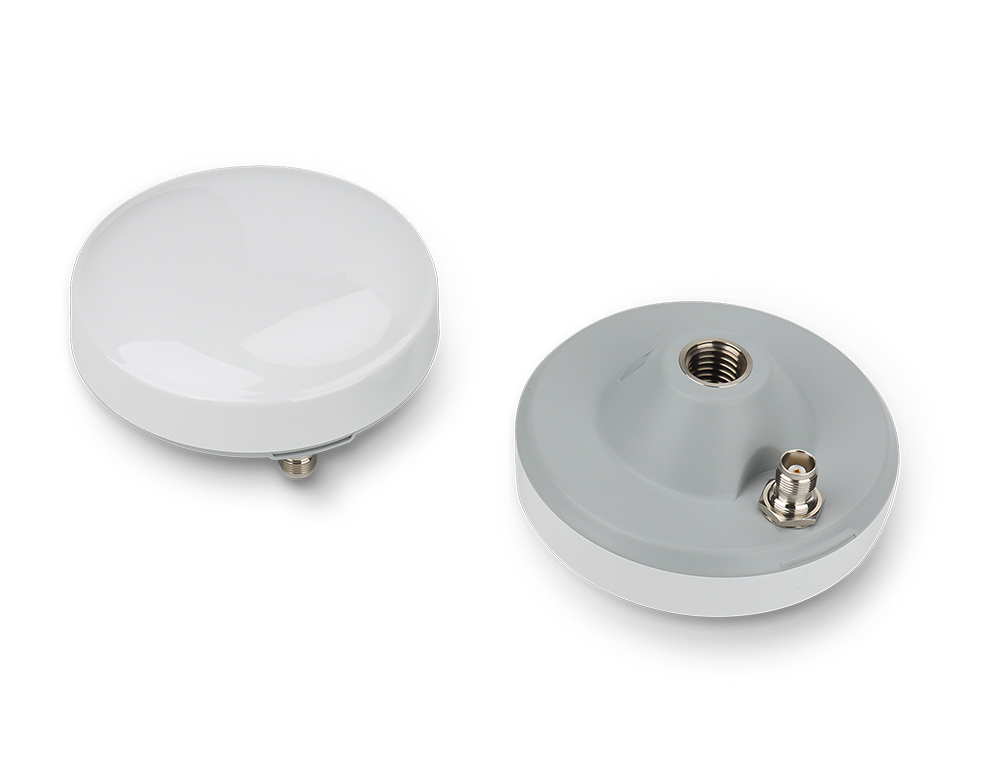
Swegeo SA20
Survey GNSS Antenna
Key Feature
- Polarization & Phase Center Performance
Swegeo SA20 is a multi-constellation and multi-frequency small form factor Survey-Grade GNSS antenna that supports GPS, GLONASS, GALILEO, BEIDOU, QZSS, IRNSS, SBAS and L-Band.
High Gain Reception & Reliable Low-Noise Amplifier for Optimal Satellite Tracking
It is widely used in high-precision navigation and positioning applications such as geodetic surveying/mapping, hydrographic mapping, precision agriculture, ADAS, Autonomous Driving, and Deformation monitoring where an accurate and reliable system is crucial.
Enhanced Performance and Precision
Multi-feed point ensures high performance on right-hand circular polarization and phase center stability. It further lowers the measurement errors.
Optimized Reception
The overall design provides a high gain on low-elevation satellite signal reception so that a higher number of satellites are available for position calculation.
Improved Signal Quality
Pre-filtering on the low noise amplifier effectively suppresses out-of-band interference signals and improves the reliability of the system.
Versatile and Durable
The enclosure is rated IP67 which ensures a reliable performance in any harsh environmental conditions.
Geodetic Surveying & Mapping:
The SA20 is a compact survey-grade antenna that surveyors use for high-accuracy GNSS measurements in the field. It can be mounted on a standard 5/8"-11 surveyor’s pole or tripod, making it suitable for tasks like topographic surveying, construction staking, or control network establishment. Surveyors appreciate that despite its smaller size, the SA20 provides the kind of low-multipath, stable phase center needed for millimeter-level work (like establishing benchmarks or monitoring ground movement). Whether it’s mapping a new road alignment or gathering data for a cadastral boundary, the SA20 delivers consistent results. Its multi-point feed design and strong pre-filtered LNA give confidence that even near RF noise or reflective surfaces, the antenna will perform without significant measurement bias.
Hydrographic and Marine Surveys:
The SA20’s robust build and high precision make it a good fit for mounting on survey boats or buoy-based GNSS units. In hydrographic mapping of a lake or coastal area, a SA20 on the boat’s mast will capture satellite signals from horizon to horizon, helping maintain RTK fix as the boat moves and rotates. The secure mounting thread and IP67 housing mean it can handle spray, weather, and constant motion. When paired with an echo-sounder system (like Swegeo’s DS100D or similar), the SA20 ensures the position tagged to each depth reading is as accurate as possible, which is crucial for producing reliable bathymetric charts or guiding dredging operations.
Precision Agriculture & Machine Control:
The SA20 can also be installed on agricultural vehicles or construction machines where a full-size survey antenna is desired but space is slightly constrained. For example, a self-driving tractor kit might use the SA20 on the roof to receive RTK corrections and navigate farm rows with 2–3 cm accuracy. The antenna’s ability to track all frequencies (including L-band for services like TerraStar or SBAS) gives farmers flexibility in correction sources. In construction, a grading machine or paver could mount an SA20 to tie into a GPS machine control system, ensuring each pass is laid down to the correct elevation and position. The antenna’s durability allows it to stay on the machine full-time, enduring vibration, heat, and dust on active job sites.


| Feature | Specification | Feature | Specification |
|---|---|---|---|
| Signal Supported |
GPS: L1/L2/L5 GLONASS: G1/G2/G3 BEIDOU: B1/B2/B3 GALILEO: E1/E5a/E5b/E6 QZSS: L1/L2/L5 IRNSS: L1/L2/L5 SBAS: L1/L2/L5 L-Band |
Architecture | Dual 4-point-feed, Dual Stacked Patch |
| Nominal Impedance | 50 Ω | Polarization | RHCP |
| Axial Ratio @ zenith | ≤1.5 dB | Gain @ zenith | ≥5.0 dBi @ Fc |
| Dimensions | Φ106 mm × 55 mm | Connector | TNC (Female) |
| Weight | 290 gram | Radome | PC-PB |
| Attachment | 5/8-11 | Frequency Range | 1164 MHz ~ 1300 MHz, 1525 MHz ~ 1621 MHz |
| LNA Gain* | 40 ±3.0 dB @25°C Typ. | Noise Figure* | ≤2.0 dB @25°C Typ. (Pre-filtered) |
| Output VSWR | ≤1.8:1 typ., 2.0:1 max | Operation Voltage | 3.0 – 6.0 VDC |
| Operation Current | ≈45 mA | Output of Band Rejection |
L5/E5/L2/G2/B2: <1050 MHz: >55 dB <1125 MHz: >30 dB >1350 MHz: >55 dB L1/E1/B1/G1: <1450 MHz: >40 dB <1690 MHz: >40 dB >1730 MHz: >45 dB |
| Operating Temperature | -40°C to +85°C | Storage Temperature | -45°C to +85°C |
| Humidity | 95% Non-condensing | Ingress Rating | IP67 |
Swegeo SA20
Helical GNSS Antenna
Key Feature
- Polarization & Phase Center Performance
Swegeo SA20 is a multi-constellation and multi-frequency small form factor Survey-Grade GNSS antenna that supports GPS, GLONASS, GALILEO, BEIDOU, QZSS, IRNSS, SBAS and L-Band.
OVERVIEW
High Gain Reception & Reliable Low-Noise Amplifier for Optimal Satellite Tracking
It is widely used in high-precision navigation and positioning applications such as geodetic surveying/mapping, hydrographic mapping, precision agriculture, ADAS, Autonomous Driving, and Deformation monitoring where an accurate and reliable system is crucial.
Enhanced Performance and Precision
Multi-feed point ensures high performance on right-hand circular polarization and phase center stability. It further lowers the measurement errors.
Optimized Reception
The overall design provides a high gain on low-elevation satellite signal reception so that a higher number of satellites are available for position calculation.
Improved Signal Quality
Pre-filtering on the low noise amplifier effectively suppresses out-of-band interference signals and improves the reliability of the system.
Versatile and Durable
The enclosure is rated IP67 which ensures a reliable performance in any harsh environmental conditions.
USE CASES
Geodetic Surveying & Mapping:
The SA20 is a compact survey-grade antenna that surveyors use for high-accuracy GNSS measurements in the field. It can be mounted on a standard 5/8"-11 surveyor’s pole or tripod, making it suitable for tasks like topographic surveying, construction staking, or control network establishment. Surveyors appreciate that despite its smaller size, the SA20 provides the kind of low-multipath, stable phase center needed for millimeter-level work (like establishing benchmarks or monitoring ground movement). Whether it’s mapping a new road alignment or gathering data for a cadastral boundary, the SA20 delivers consistent results. Its multi-point feed design and strong pre-filtered LNA give confidence that even near RF noise or reflective surfaces, the antenna will perform without significant measurement bias.
Hydrographic and Marine Surveys:
The SA20’s robust build and high precision make it a good fit for mounting on survey boats or buoy-based GNSS units. In hydrographic mapping of a lake or coastal area, a SA20 on the boat’s mast will capture satellite signals from horizon to horizon, helping maintain RTK fix as the boat moves and rotates. The secure mounting thread and IP67 housing mean it can handle spray, weather, and constant motion. When paired with an echo-sounder system (like Swegeo’s DS100D or similar), the SA20 ensures the position tagged to each depth reading is as accurate as possible, which is crucial for producing reliable bathymetric charts or guiding dredging operations.
Precision Agriculture & Machine Control:
The SA20 can also be installed on agricultural vehicles or construction machines where a full-size survey antenna is desired but space is slightly constrained. For example, a self-driving tractor kit might use the SA20 on the roof to receive RTK corrections and navigate farm rows with 2–3 cm accuracy. The antenna’s ability to track all frequencies (including L-band for services like TerraStar or SBAS) gives farmers flexibility in correction sources. In construction, a grading machine or paver could mount an SA20 to tie into a GPS machine control system, ensuring each pass is laid down to the correct elevation and position. The antenna’s durability allows it to stay on the machine full-time, enduring vibration, heat, and dust on active job sites.
APPLICATIONS
TECHNICAL SPECIFICATIONS
| Feature | Specification | Feature | Specification |
|---|---|---|---|
| Signal Supported |
GPS: L1/L2/L5 GLONASS: G1/G2/G3 BEIDOU: B1/B2/B3 GALILEO: E1/E5a/E5b/E6 QZSS: L1/L2/L5 IRNSS: L1/L2/L5 SBAS: L1/L2/L5 L-Band |
Architecture | Dual 4-point-feed, Dual Stacked Patch |
| Nominal Impedance | 50 Ω | Polarization | RHCP |
| Axial Ratio @ zenith | ≤1.5 dB | Gain @ zenith | ≥5.0 dBi @ Fc |
| Dimensions | Φ106 mm × 55 mm | Connector | TNC (Female) |
| Weight | 290 gram | Radome | PC-PB |
| Attachment | 5/8-11 | Frequency Range | 1164 MHz ~ 1300 MHz, 1525 MHz ~ 1621 MHz |
| LNA Gain* | 40 ±3.0 dB @25°C Typ. | Noise Figure* | ≤2.0 dB @25°C Typ. (Pre-filtered) |
| Output VSWR | ≤1.8:1 typ., 2.0:1 max | Operation Voltage | 3.0 – 6.0 VDC |
| Operation Current | ≈45 mA | Output of Band Rejection |
L5/E5/L2/G2/B2: <1050 MHz: >55 dB <1125 MHz: >30 dB >1350 MHz: >55 dB L1/E1/B1/G1: <1450 MHz: >40 dB <1690 MHz: >40 dB >1730 MHz: >45 dB |
| Operating Temperature | -40°C to +85°C | Storage Temperature | -45°C to +85°C |
| Humidity | 95% Non-condensing | Ingress Rating | IP67 |