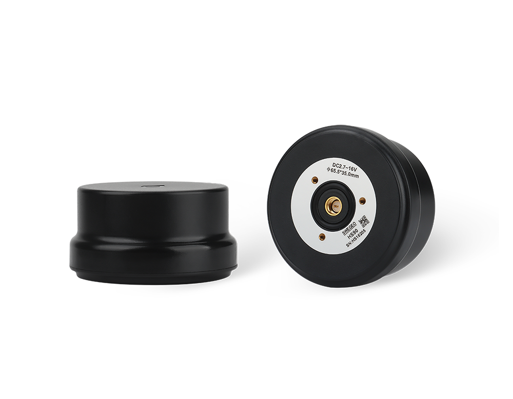
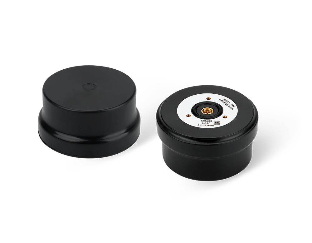
Swegeo HS90
Helical GNSS Antenna
Key Feature
The Swegeo HS90 is a high-performance GNSS spiral antenna designed with multi-arm, multi-feed point technology.
It supports multi-constellation and multi-frequency signals, ensuring robust and accurate positioning.
Compatible systems include GPS, GLONASS, GALILEO, BEIDOU, QZSS, IRNSS, SBAS, and L-Band.
Multi-Constellation GNSS Support
Provides reliable and robust signal reception from GPS, GLONASS, Galileo, and
BeiDou systems, ensuring comprehensive coverage and improved accuracy.
Dual Antenna Configuration
Enhances positioning accuracy and performance, particularly in challenging
environments, by using two antennas to better mitigate signal obstructions and
multipath effects.
Rugged Design with IP67 Rating
Features a durable and weather-resistant enclosure, suitable for various
demanding applications and harsh conditions.
High Update Rate and Low Latency
Offers real-time data with minimal delay, providing timely and accurate
positioning information for critical operations.
Integrated Communication Interfaces
Facilitates seamless integration into existing systems with various
communication options, enhancing connectivity and ease of use.
Industrial & Robotics Platforms:
The HS90 antenna is a low-profile helical designed for high precision in tough electromagnetic environments, making it ideal for industrial robots and vehicles operating around heavy machinery or radio sources. For example, an autonomous warehouse forklift or a port-side robot can utilize the HS90 to navigate precisely despite nearby wireless networks or metal structures. Its multi-stage filtering and out-of-band rejection (65 dB) protect against interference from things like vehicle radios, LTE towers, or industrial IoT devices, ensuring the robot’s GNSS guidance remains accurate and stable. The antenna’s small size and screw mount allow it to be securely installed on moving equipment where vibration is present – and its robust design will keep tracking satellites under those conditions.
Surveying in Urban/EMI-Prone Areas:
Surveyors working in cities or near broadcast towers often face interference that can disrupt GNSS measurements. Using the HS90 on their rover or reference receiver helps mitigate this problem. For instance, a surveyor doing control point measurements in a city center could attach an HS90 to their pole; the antenna’s exceptional interference suppression filters out signals from nearby cell towers or TV transmitters that might otherwise cause position jumps. Additionally, its high gain and ability to hold lock in multipath-rich environments (with buildings reflecting signals) means fewer dropped fixes when surveying street corridors or near tall structures. This translates to more reliable data and less time spent waiting for the receiver to re-initialize.
UAVs & Vehicles in Challenging RF Environments:
Drones that must operate near high-power transmitters or vehicles with a lot of onboard electronics benefit from the HS90’s anti-jam design. Consider a drone inspecting a radio tower or flying near a radar installation – a typical antenna might struggle, but the HS90’s integrated filters will maintain signal quality, allowing the drone to keep its RTK solution and complete the mission. Similarly, a military or emergency-response vehicle equipped with multiple antennas (communications, GNSS, etc.) can use an HS90 for its navigation receiver to avoid self-interference. The antenna’s ability to provide reliable, high-precision data in these demanding scenarios makes it a trusted component for mission-critical systems.


| Feature | Specification | Feature | Specification |
|---|---|---|---|
| Signal Supported |
GPS: L1/L2/L5 GLONASS: G1/G2/G3 BEIDOU: B1/B2/B3 GALILEO: E1/E5a/E5b/E6 QZSS: L1/L2/L5 IRNSS: L1/L2/L5 SBAS: L1/L2/L5 L-Band |
Architecture | Quadrifilar Helix |
| Nominal Impedance | 50 Ω | Polarization | RHCP |
| Axial Ratio @ zenith | ≤1.5 dB | Gain @ zenith | ≥2.5 dBi |
| Dimensions | Φ65.5 mm × 35.0 mm | Connector | SMA-J |
| Weight | 40 gram | Radome | EXL9330 |
| Attachment | Screws | Frequency Range | 1164 MHz ~ 1300 MHz, 1540 MHz ~ 1606 MHz |
| LNA Gain* | 32 ±3.0 dB (Typ. @25°C, 2.7VDC~16VDC) | Output VSWR | ≤1.8:1 typ., 2.0:1 max |
| Operation Voltage | 2.5 ~ 16.0 V DC (Recommend 2.7 VDC ~ 16 VDC) | Operation Current | ≤45 mA |
| Output of Band Rejection |
≤1050 MHz: >65 dB @1400 MHz: >60 dB ≥1690 MHz: >65 dB |
Operating Temperature | -40°C to +85°C |
| Storage Temperature | -45°C to +85°C | Humidity | 95% Non-condensing |
| Ingress Rating | IP67 |
Swegeo HS90
Helical GNSS Antenna
Key Feature
The Swegeo HS90 is a high-performance GNSS spiral antenna designed with multi-arm, multi-feed point technology.
It supports multi-constellation and multi-frequency signals, ensuring robust and accurate positioning.
Compatible systems include GPS, GLONASS, GALILEO, BEIDOU, QZSS, IRNSS, SBAS, and L-Band.
OVERVIEW
Multi-Constellation GNSS Support
Provides reliable and robust signal reception from GPS, GLONASS, Galileo, and
BeiDou systems, ensuring comprehensive coverage and improved accuracy.
Dual Antenna Configuration
Enhances positioning accuracy and performance, particularly in challenging
environments, by using two antennas to better mitigate signal obstructions and
multipath effects.
USE CASES
Industrial & Robotics Platforms:
The HS90 antenna is a low-profile helical designed for high precision in tough electromagnetic environments, making it ideal for industrial robots and vehicles operating around heavy machinery or radio sources. For example, an autonomous warehouse forklift or a port-side robot can utilize the HS90 to navigate precisely despite nearby wireless networks or metal structures. Its multi-stage filtering and out-of-band rejection (65 dB) protect against interference from things like vehicle radios, LTE towers, or industrial IoT devices, ensuring the robot’s GNSS guidance remains accurate and stable. The antenna’s small size and screw mount allow it to be securely installed on moving equipment where vibration is present – and its robust design will keep tracking satellites under those conditions.
Surveying in Urban/EMI-Prone Areas:
Surveyors working in cities or near broadcast towers often face interference that can disrupt GNSS measurements. Using the HS90 on their rover or reference receiver helps mitigate this problem. For instance, a surveyor doing control point measurements in a city center could attach an HS90 to their pole; the antenna’s exceptional interference suppression filters out signals from nearby cell towers or TV transmitters that might otherwise cause position jumps. Additionally, its high gain and ability to hold lock in multipath-rich environments (with buildings reflecting signals) means fewer dropped fixes when surveying street corridors or near tall structures. This translates to more reliable data and less time spent waiting for the receiver to re-initialize.
UAVs & Vehicles in Challenging RF Environments:
Drones that must operate near high-power transmitters or vehicles with a lot of onboard electronics benefit from the HS90’s anti-jam design. Consider a drone inspecting a radio tower or flying near a radar installation – a typical antenna might struggle, but the HS90’s integrated filters will maintain signal quality, allowing the drone to keep its RTK solution and complete the mission. Similarly, a military or emergency-response vehicle equipped with multiple antennas (communications, GNSS, etc.) can use an HS90 for its navigation receiver to avoid self-interference. The antenna’s ability to provide reliable, high-precision data in these demanding scenarios makes it a trusted component for mission-critical systems.
APPLICATIONS
TECHNICAL SPECIFICATIONS
| Feature | Specification | Feature | Specification |
|---|---|---|---|
| Signal Support (Primary RF) |
GPS L1 C/A, L1C, L2C, L2P, L5; GLONASS L1 C/A, L2 C/A, L2P, L3, L5; Galileo E1, E5 AltBOC, E5a, E5b; BeiDou B1I, B1C, B2I, B2a, B2b; QZSS L1 C/A, L1C, L1S, L2C, L5; NavIC (IRNSS) L5; SBAS L1, L5; L-Band up to 5 channels |
Signal Support (Secondary RF) |
GPS L1 C/A, L1C, L2C, L2P, L5; GLONASS L1 C/A, L2 C/A, L2P, L3, L5; Galileo E1, E5 AltBOC, E5a, E5b; BeiDou B1I, B1C, B2I, B2a, B2b; QZSS L1 C/A, L1C, L1S, L2C, L5; NavIC (IRNSS) L5 |
| Horizontal Position Accuracy (RMS) |
Single point L1 1.5 m Single point L1/L2 1.2 m SBAS 60 cm DGPS 40 cm TerraStar-L 40 cm TerraStar-C PRO 2.5 cm RTK 1 cm + 1 ppm ALIGN heading accuracy |
Baseline Accuracy (RMS) |
2 m 0.08° 4 m 0.0° |
| Data Update Rate |
Measurements up to 100 Hz Position up to 100 Hz |
Time to First Fix |
Cold start < 34 s (typ) Hot start < 20 s (typ) |
| Signal Reacquisition |
L1 < 0.5 s (typ) L2 < 1.0 s (typ) |
Velocity Limit | 600 m/s |
| Velocity Accuracy | <0.03 m/s RMS | Time Accuracy | <5 ns RMS |
| Dimensions | 147 x 125 x 55 mm | Weight | 500 g |
| Power Consumption | 3.95 W | Input Voltage | +9 to +36 VDC |
| 2 Antenna LNA Power Output |
Output voltage 5 VDC ±5% Maximum current 200 mA |
Connectors |
RF 2×TNC USB M12-USB TYPE A Cable Serial M12-2×DB9Y Cable Power M12-3 Wire Cable |
| Status LED | Position Valid, Power, Serial Rx/Tx Stream | Ingress Protection Rating | IP67 |
| Temperature |
Operating -40°C to +75°C Storage -40°C to +85°C |
Humidity | 95% non-condensing |
| Vibration |
Random MIL-STD-810H, Method 514.8 (Cat 24, 20 g RMS) Sinusoidal IEC 60068-2-6 |
Shock / Bump / Acceleration |
Acceleration: MIL-STD-810H, Method 513.8, Procedure II (16 g) Bump: MIL-STD-810H, Method 516.8, Procedure 1 (40 g 11 ms terminal sawtooth) Shock: Random MIL-STD-810H, Method 514.8 (Cat 24, 20 g RMS), Sinusoidal IEC 60068-2-6 |