
Swegeo SS100D
Dual Antenna GNSS Receiver Sensor
Key Feature
- Equipped with multi-GNSS support, it provides reliable and stable satellite signal reception from GPS, GLONASS, Galileo and BeiDou systems.
- It is suitable for various harsh environments thanks to its robust design and IP67 class housing.
- The receiver’s high update rate, low latency and integrated communication interfaces allow for seamless integration into your existing systems.
Multi-Constellation GNSS Support
Provides reliable and robust signal reception from GPS, GLONASS, Galileo, and
BeiDou systems, ensuring comprehensive coverage and improved accuracy.
Dual Antenna Configuration
Enhances positioning accuracy and performance, particularly in challenging
environments, by using two antennas to better mitigate signal obstructions and
multipath effects.
Rugged Design with IP67 Rating
Features a durable and weather-resistant enclosure, suitable for various
demanding applications and harsh conditions.
High Update Rate and Low Latency
Offers real-time data with minimal delay, providing timely and accurate
positioning information for critical operations.
Integrated Communication Interface
Facilitates seamless integration into existing systems with various
communication options, enhancing connectivity and ease of use.
Precision Land Surveying & Mapping:
Surveyors can deploy the SS100D as an RTK base station or rover to achieve centimeter-level accuracy. Its dual-antenna setup provides accurate heading, which is invaluable when establishing orientation of survey equipment or mapping infrastructure in real time. The rugged, IP67 design means it performs reliably on remote job sites and under harsh environmental conditions.
Autonomous Vehicles & Robotics:
UAV integrators and robotics engineers use the SS100D to equip drones, driverless cars, and unmanned robots with precise positioning and heading. The dual GNSS antennas allow an autonomous platform to know its direction even before moving, which is crucial for tasks like self-driving navigation, robotic path planning, and maintaining steady course in agricultural machines. High update rates with low latency ensure the sensor keeps up with fast vehicle dynamics, enabling lane-level navigation and stable flight paths for drones.
Marine & Machine Control:
The SS100D is ideal for marine vessels and construction machinery that require both accurate location and orientation. For example, on marine survey boats or port vehicles, two antennas provide true heading independent of magnetic compasses, improving guidance for dredging or harbor navigation. In construction and mining, the receiver can be mounted on heavy equipment (like bulldozers or cranes) to deliver real-time position and heading for automated blade control or crane alignment, enhancing both precision and safety in operations.


| Feature | Specification | Feature | Specification |
|---|---|---|---|
| Primary RF |
GPS L1 C/A, L1C, L2C, L2P, L5 GLONASS3 L1 C/A, L2 C/A, L2P, L3, L5 Galileo4 E1, E5 AltBOC, E5a, E5b BeiDou B1I, B1C, B2I, B2a, B2b QZSS L1 C/A, L1C, L1S, L2C, L5 NavIC (IRNSS) L5 SBAS L1, L5 L-Band up to 5 channels |
Secondary RF |
GPS L1 C/A, L1C, L2C, L2P, L5 GLONASS3 L1 C/A, L2 C/A, L2P, L3, L5 Galileo4 E1, E5 AltBOC, E5a, E5b BeiDou B1I, B1C, B2I, B2a, B2b QZSS L1 C/A, L1C, L1S, L2C, L5 NavIC (IRNSS) L5 |
| Accuracy (Yatay Pozisyon RMS) |
Single point L1 1.5 m Single point L1/L2 1.2 m SBAS5 60 cm DGPS 40 cm TerraStar-L6 40 cm TerraStar-C PRO6 2.5 cm RTK 1 cm + 1 ppm ALIGN heading accuracy |
Baseline Accuracy (RMS) |
2 m 0.08° 4 m 0.0 |
| Data Update Rate |
Measurements up to 100 Hz Position up to 100 Hz |
Initialization / Time to first fix |
Cold start < 34 s (typ) Hot start < 20 s (typ) |
| Signal Reacquisition |
L1 < 0.5 s (typ) L2 < 1.0 s (typ) |
Velocity Limit | 600 m/s |
| Velocity Accuracy | < 0.03 m/s RMS | Time Accuracy | < 5 ns RMS |
| Dimensions | 147 x 125 x 55 mm | Weight | 500 g |
| Power Consumption | 3.95 W | Input Voltage | +9 to +36 VDC |
| 2 Antenna LNA Power Output |
Output voltage 5 VDC ±5% Maximum current 200 mA |
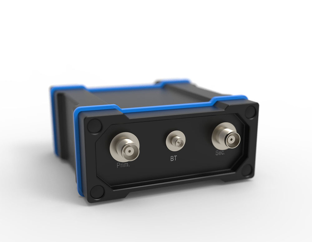
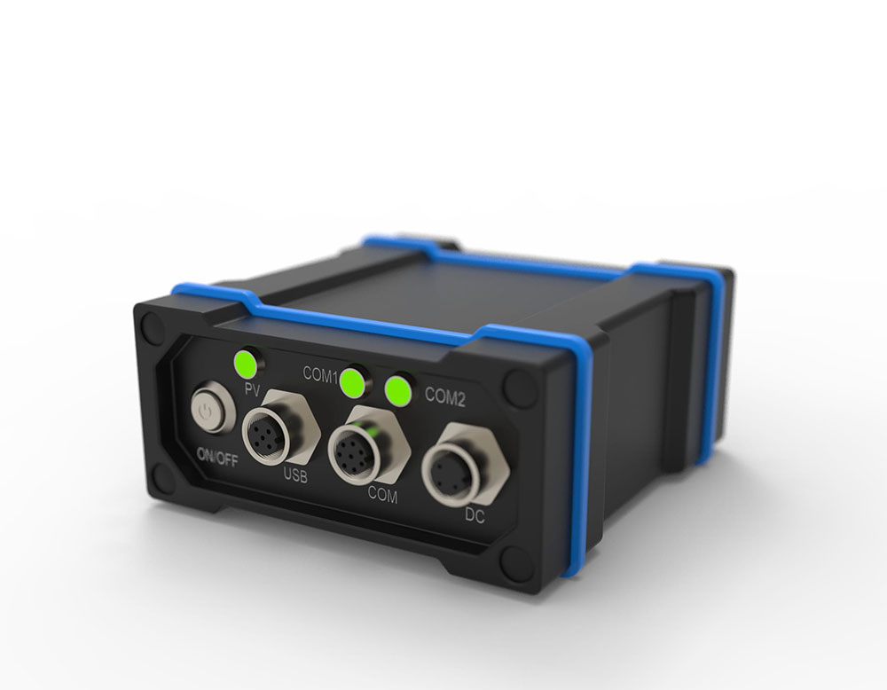
Connectors |
RF 2×TNC USB M12-USB TYPE A Cable Serial M12-2×DB9Y Cable Power M12-3 Wire Cable |
| Status Led |
Position Valid Power Serial Rx/Tx Stream |
Temperature |
Operating -40°C to +75°C Storage -40°C to +85°C |
| Humidity | 95% non-condensing | Ingress Protection Rating | IP67 |
| Vibration |
Random MIL-STD-810H, Method 514.8 (Cat 24, 20 g RMS) Sinusoidal IEC 60068-2-6 |
Acceleration | MIL-STD-810H, Method 513.8, Procedure II (16 g) |
| Bump | MIL-STD-810H, Method 516.8, Procedure 1, 40 g 11 ms terminal sawtooth | Shock |
Random MIL-STD-810H, Method 514.8 (Cat 24, 20 g RMS) Sinusoidal IEC 60068-2-6 |
Swegeo SS100D
Dual Antenna GNSS Receiver Sensor
Key Feature
- Equipped with multi-GNSS support, it provides reliable and stable satellite signal reception from GPS, GLONASS, Galileo and BeiDou systems.
- It is suitable for various harsh environments thanks to its robust design and IP67 class housing.
- The receiver’s high update rate, low latency and integrated communication interfaces allow for seamless integration into your existing systems.
OVERVIEW
Multi-Constellation GNSS Support
Provides reliable and robust signal reception from GPS, GLONASS, Galileo, and
BeiDou systems, ensuring comprehensive coverage and improved accuracy.
Dual Antenna Configuration
Enhances positioning accuracy and performance, particularly in challenging
environments, by using two antennas to better mitigate signal obstructions and
multipath effects.
USE CASES
Precision Land Surveying & Mapping:
Surveyors can deploy the SS100D as an RTK base station or rover to achieve centimeter-level accuracy. Its dual-antenna setup provides accurate heading, which is invaluable when establishing orientation of survey equipment or mapping infrastructure in real time. The rugged, IP67 design means it performs reliably on remote job sites and under harsh environmental conditions.
Autonomous Vehicles & Robotics:
UAV integrators and robotics engineers use the SS100D to equip drones, driverless cars, and unmanned robots with precise positioning and heading. The dual GNSS antennas allow an autonomous platform to know its direction even before moving, which is crucial for tasks like self-driving navigation, robotic path planning, and maintaining steady course in agricultural machines. High update rates with low latency ensure the sensor keeps up with fast vehicle dynamics, enabling lane-level navigation and stable flight paths for drones.
Marine & Machine Control:
The SS100D is ideal for marine vessels and construction machinery that require both accurate location and orientation. For example, on marine survey boats or port vehicles, two antennas provide true heading independent of magnetic compasses, improving guidance for dredging or harbor navigation. In construction and mining, the receiver can be mounted on heavy equipment (like bulldozers or cranes) to deliver real-time position and heading for automated blade control or crane alignment, enhancing both precision and safety in operations.
APPLICATIONS
TECHNICAL SPECIFICATIONS
| Feature | Specification | Feature | Specification |
|---|---|---|---|
| Primary RF |
GPS L1 C/A, L1C, L2C, L2P, L5 GLONASS3 L1 C/A, L2 C/A, L2P, L3, L5 Galileo4 E1, E5 AltBOC, E5a, E5b BeiDou B1I, B1C, B2I, B2a, B2b QZSS L1 C/A, L1C, L1S, L2C, L5 NavIC (IRNSS) L5 SBAS L1, L5 L-Band up to 5 channels |
Secondary RF |
GPS L1 C/A, L1C, L2C, L2P, L5 GLONASS3 L1 C/A, L2 C/A, L2P, L3, L5 Galileo4 E1, E5 AltBOC, E5a, E5b BeiDou B1I, B1C, B2I, B2a, B2b QZSS L1 C/A, L1C, L1S, L2C, L5 NavIC (IRNSS) L5 |
| Accuracy (Yatay Pozisyon RMS) |
Single point L1 1.5 m Single point L1/L2 1.2 m SBAS5 60 cm DGPS 40 cm TerraStar-L6 40 cm TerraStar-C PRO6 2.5 cm RTK 1 cm + 1 ppm ALIGN heading accuracy |
Baseline Accuracy (RMS) |
2 m 0.08° 4 m 0.0 |
| Data Update Rate |
Measurements up to 100 Hz Position up to 100 Hz |
Initialization / Time to first fix |
Cold start < 34 s (typ) Hot start < 20 s (typ) |
| Signal Reacquisition |
L1 < 0.5 s (typ) L2 < 1.0 s (typ) |
Velocity Limit | 600 m/s |
| Velocity Accuracy | < 0.03 m/s RMS | Time Accuracy | < 5 ns RMS |
| Dimensions | 147 x 125 x 55 mm | Weight | 500 g |
| Power Consumption | 3.95 W | Input Voltage | +9 to +36 VDC |
| 2 Antenna LNA Power Output |
Output voltage 5 VDC ±5% Maximum current 200 mA |
Connectors |
RF 2×TNC USB M12-USB TYPE A Cable Serial M12-2×DB9Y Cable Power M12-3 Wire Cable |
| Status Led |
Position Valid Power Serial Rx/Tx Stream |
Temperature |
Operating -40°C to +75°C Storage -40°C to +85°C |
| Humidity | 95% non-condensing | Ingress Protection Rating | IP67 |
| Vibration |
Random MIL-STD-810H, Method 514.8 (Cat 24, 20 g RMS) Sinusoidal IEC 60068-2-6 |
Acceleration | MIL-STD-810H, Method 513.8, Procedure II (16 g) |
| Bump | MIL-STD-810H, Method 516.8, Procedure 1, 40 g 11 ms terminal sawtooth | Shock |
Random MIL-STD-810H, Method 514.8 (Cat 24, 20 g RMS) Sinusoidal IEC 60068-2-6 |