

Swegeo SS100S
Single Antenna GNSS Receiver Sensor
Key Feature
- Equipped with multi-GNSS support, it provides reliable and stable satellite signal reception from GPS, GLONASS, Galileo and BeiDou systems.
- It is suitable for various harsh environments thanks to its robust design and IP67 class housing.
- The receiver’s high update rate, low latency and integrated communication interfaces allow for seamless integration into your existing systems.
Multi-Constellation GNSS Support
Ensures reliable and robust signal reception from GPS, GLONASS, Galileo, and BeiDou systems, providing comprehensive coverage and improved accuracy.
Rugged Design with IP67 Rating
Features a durable and weather-resistant enclosure, making it suitable for harsh and demanding environments.
High Update Rate and Low Latency
Offers real-time data with minimal delay, providing timely and accurate
positioning information for critical operations.
Integrated Communication Interfaces
Facilitates seamless integration into existing systems with various
communication options, enhancing connectivity and ease of use.
General RTK Positioning for Surveying:
With its multi-constellation, multi-frequency RTK support, the SS100S serves as a reliable GNSS rover for land surveyors and GIS professionals. It delivers precise coordinates for mapping property boundaries, engineering projects, or GIS data collection. Survey teams can use it on a pole or tripod to log points with centimeter accuracy, or as a compact reference station broadcasting corrections to other rovers.
Precision Agriculture:
Agricultural operators integrate the SS100S into tractor guidance and crop management systems for high-precision navigation in the field. The single-antenna design provides the necessary accuracy for auto-steering tractors along crop rows, controlling seed planting or fertilizer application with minimal overlap. Its rugged enclosure and low latency outputs ensure it works flawlessly through dust, vibration, and long days in the field, guiding farm machinery with sub-decimeter precision.
Industrial Automation & Drones:
The SS100S is well-suited for any moving machine or drone that needs exact positioning but can rely on other sensors for orientation. Automated guided vehicles in warehouses, for instance, use the SS100S to track their location within a yard or facility. Likewise, many UAVs performing mapping or inspection carry this sensor to geo-tag images and control flight routes. Its lightweight, power-efficient design and integrated communications interfaces simplify embedding it into drone autopilots or robot control systems.


| Feature | Specification | Feature | Specification |
|---|---|---|---|
| Signal Support (Primary RF) |
GPS L1 C/A, L1C, L2C, L2P, L5; GLONASS L1 C/A, L2 C/A, L2P, L3, L5; Galileo E1, E5 AltBOC, E5a, E5b, E6; BeiDou B1I, B1C, B2I, B2a, B2b, B3I; QZSS L1 C/A, L1C, L1S, L2C, L5, L6; NavIC (IRNSS) L5; SBAS L1, L5; L-Band up to 5 channels |
Horizontal Position Accuracy (RMS) |
Single point L1: 1.5 m Single point L1/L2: 1.2 m SBAS: 60 cm DGPS: 40 cm TerraStar-L: 40 cm TerraStar-C PRO: 2.5 cm TerraStar-X: 2 cm RTK: 1 cm + 1 ppm |
| Data Update Rate |
Measurements: up to 100 Hz Position: up to 100 Hz |
Time to First Fix |
Cold start: < 34 s (typ) Hot start: < 20 s (typ) |
| Signal Reacquisition |
L1: < 0.5 s (typ) L2: < 1.0 s (typ) |
Velocity Limit | 600 m/s |
| Velocity Accuracy | < 0.03 m/s RMS | Time Accuracy | < 5 ns RMS |
| Dimensions | 147 x 125 x 55 mm | Weight | 500 g |
| Power Consumption | 3.25 W | Input Voltage | +9 to +36 VDC |
| 2 Antenna LNA Power Output |
Output voltage: 5 VDC ±5% Max current: 200 mA |
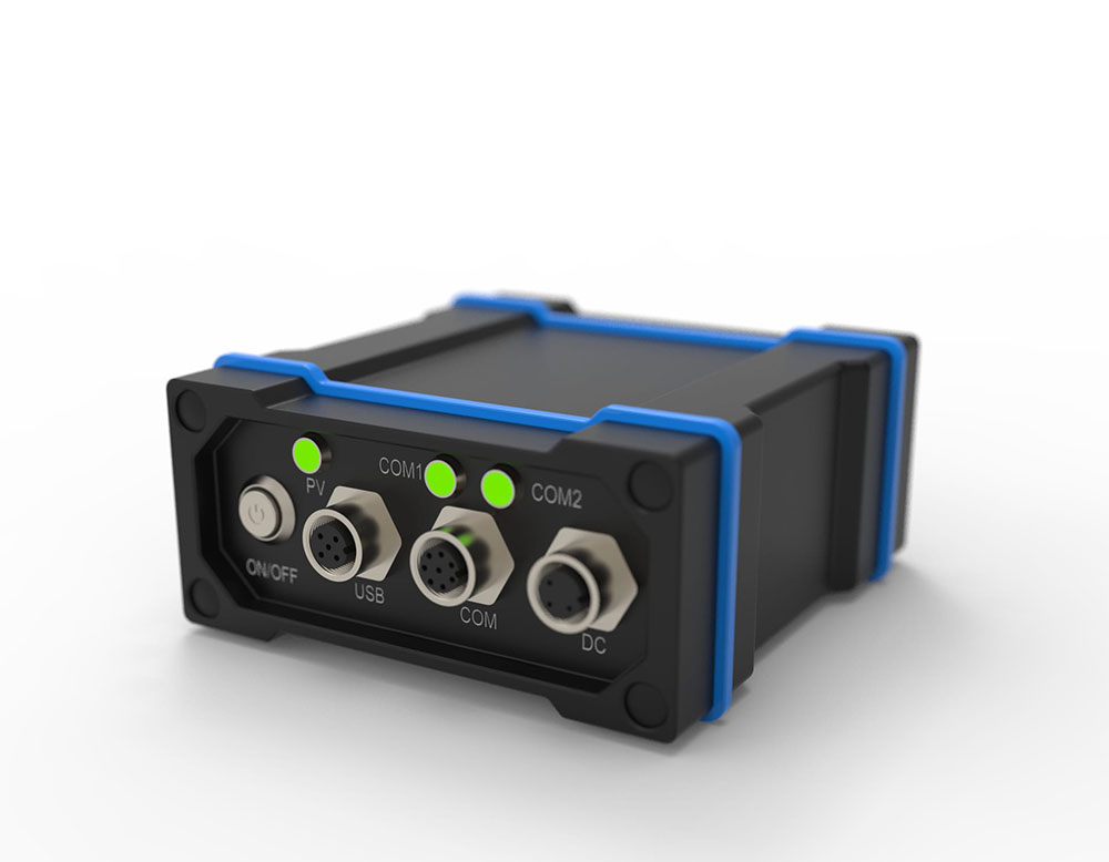
Connectors |
RF: 1×TNC USB: M12-USB TYPE A Cable Serial: M12-2×DB9Y Cable Power: M12-3 Wire Cable |
| Status LED | Position Valid, Power, Serial Rx/Tx Stream | Ingress Protection Rating | IP68 |
| Temperature |
Operating: -40°C to +75°C Storage: -40°C to +85°C |
Humidity | 95% non-condensing |
| Vibration |
Random: MIL-STD-810H, Method 514.8 (Cat 24, 20 g RMS) Sinusoidal: IEC 60068-2-6 |
Acceleration / Bump / Shock |
Acceleration: MIL-STD-810H, Method 513.8, Procedure II (16 g) Bump: IEC 60068-2-27 (25 g) Shock: MIL-STD-810H, Method 516.8, Procedure 1 (40 g, 11 ms terminal sawtooth) |
Swegeo SS100S
Dual Antenna GNSS Receiver Sensor
Key Feature
- Equipped with multi-GNSS support, it provides reliable and stable satellite signal reception from GPS, GLONASS, Galileo and BeiDou systems.
- It is suitable for various harsh environments thanks to its robust design and IP67 class housing.
- The receiver’s high update rate, low latency and integrated communication interfaces allow for seamless integration into your existing systems.
OVERVIEW
Multi-Constellation GNSS Support
Provides reliable and robust signal reception from GPS, GLONASS, Galileo, and
BeiDou systems, ensuring comprehensive coverage and improved accuracy.
Dual Antenna Configuration
Enhances positioning accuracy and performance, particularly in challenging
environments, by using two antennas to better mitigate signal obstructions and
multipath effects.
USE CASES
General RTK Positioning for Surveying:
With its multi-constellation, multi-frequency RTK support, the SS100S serves as a reliable GNSS rover for land surveyors and GIS professionals. It delivers precise coordinates for mapping property boundaries, engineering projects, or GIS data collection. Survey teams can use it on a pole or tripod to log points with centimeter accuracy, or as a compact reference station broadcasting corrections to other rovers.
Precision Agriculture:
Agricultural operators integrate the SS100S into tractor guidance and crop management systems for high-precision navigation in the field. The single-antenna design provides the necessary accuracy for auto-steering tractors along crop rows, controlling seed planting or fertilizer application with minimal overlap. Its rugged enclosure and low latency outputs ensure it works flawlessly through dust, vibration, and long days in the field, guiding farm machinery with sub-decimeter precision.
Industrial Automation & Drones:
The SS100S is well-suited for any moving machine or drone that needs exact positioning but can rely on other sensors for orientation. Automated guided vehicles in warehouses, for instance, use the SS100S to track their location within a yard or facility. Likewise, many UAVs performing mapping or inspection carry this sensor to geo-tag images and control flight routes. Its lightweight, power-efficient design and integrated communications interfaces simplify embedding it into drone autopilots or robot control systems.
APPLICATIONS
TECHNICAL SPECIFICATIONS
| Feature | Specification | Feature | Specification |
|---|---|---|---|
| Signal Support (Primary RF) |
GPS L1 C/A, L1C, L2C, L2P, L5; GLONASS L1 C/A, L2 C/A, L2P, L3, L5; Galileo E1, E5 AltBOC, E5a, E5b, E6; BeiDou B1I, B1C, B2I, B2a, B2b, B3I; QZSS L1 C/A, L1C, L1S, L2C, L5, L6; NavIC (IRNSS) L5; SBAS L1, L5; L-Band up to 5 channels |
Horizontal Position Accuracy (RMS) |
Single point L1: 1.5 m Single point L1/L2: 1.2 m SBAS: 60 cm DGPS: 40 cm TerraStar-L: 40 cm TerraStar-C PRO: 2.5 cm TerraStar-X: 2 cm RTK: 1 cm + 1 ppm |
| Data Update Rate |
Measurements: up to 100 Hz Position: up to 100 Hz |
Time to First Fix |
Cold start: < 34 s (typ) Hot start: < 20 s (typ) |
| Signal Reacquisition |
L1: < 0.5 s (typ) L2: < 1.0 s (typ) |
Velocity Limit | 600 m/s |
| Velocity Accuracy | < 0.03 m/s RMS | Time Accuracy | < 5 ns RMS |
| Dimensions | 147 x 125 x 55 mm | Weight | 500 g |
| Power Consumption | 3.25 W | Input Voltage | +9 to +36 VDC |
| 2 Antenna LNA Power Output |
Output voltage: 5 VDC ±5% Max current: 200 mA |
Connectors |
RF: 1×TNC USB: M12-USB TYPE A Cable Serial: M12-2×DB9Y Cable Power: M12-3 Wire Cable |
| Status LED | Position Valid, Power, Serial Rx/Tx Stream | Ingress Protection Rating | IP68 |
| Temperature |
Operating: -40°C to +75°C Storage: -40°C to +85°C |
Humidity | 95% non-condensing |
| Vibration |
Random: MIL-STD-810H, Method 514.8 (Cat 24, 20 g RMS) Sinusoidal: IEC 60068-2-6 |
Acceleration / Bump / Shock |
Acceleration: MIL-STD-810H, Method 513.8, Procedure II (16 g) Bump: IEC 60068-2-27 (25 g) Shock: MIL-STD-810H, Method 516.8, Procedure 1 (40 g, 11 ms terminal sawtooth) |